The daily CET stats are interesting in that respect
If you just look at the winter months and the Maximum Daily CET ( better than the Mean or Min for judging the likelihood of prolonged snow) you can get a list of every one of the 91 possible date records for December (31) January (31) and February (29) going back to 1878
If you then plot the date records for highest and lowest CET Maxima on that date you get :
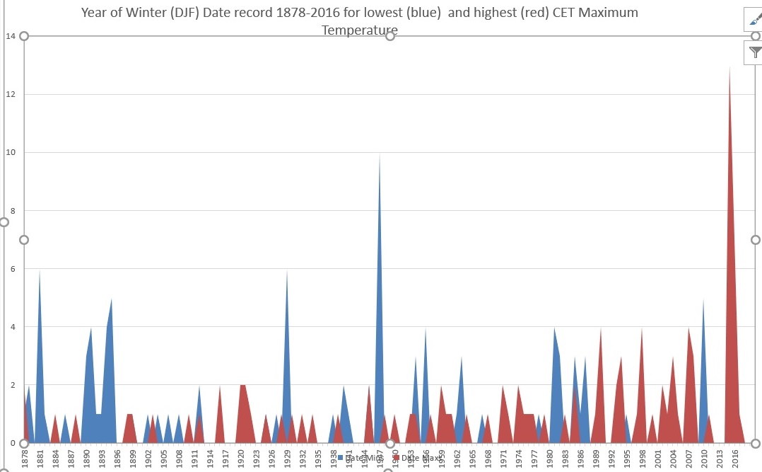
The increase in date records nearer the current date and decrease in cold date records is very clear
In fact there have only been 3 years ince 1987 with cold date records (2010, 1995, 1987) contributing 9 date records out of 91 possibles. On the other hand there have been 17 years with warm date records in that 30 years consisting of 52 of the possible 91 dates
Thanks for that. It's definitely food for thought. But I still have the problem that 10% of the cold date records have nevertheless occurred in the last 3 decades. That's 10% of the records appearing in the most recent 22% of the series.
Obviously I'm not disputing that there is a bias towards higher maxima, which, as you say, is what precludes lasting snow (and icicles, of course). But to me that is not evidence of any fundamental change since Darren's legendary 1985 easterly. Quite the opposite, if 10% of winter dates then went on to produce maxima which were lower than any previously recorded since 1878.
The point Darren makes about the jet annoyingly tending to sink the block these days rather than support it is a good one. Even last winter, which we all moaned about, was incredibly blocky. It's just that the jet insured that the block was parked to our immediate east, rather than further north over Scandinavia.
So anti-cyclonic winters are still easily possible, as last year demonstrated. The question is whether the fact that those anti-cyclones have recently tended to appear further south than previously is evidence of fundamental change, or whether that's just a roll of the dice which hasn't worked out for us as often as it used to.
I'm tending to the view that it's just one of those things - pot luck, and the blocks are still there, and one day it'll all turn out the way we want it again.
But I do sympathize with the view that a shift in jet patterns does imply that there is something different going on.
Edited by user
06 October 2017 20:08:57
|
Reason: Not specified
2 miles west of Taunton, 32 m asl, where "milder air moving in from the west" becomes SNOWMAGEDDON.
Well, two or three times a decade it does, anyway.